06 February 2024

The Ancient Peninsula of Regensburg


It is a generally accepted view among local historians in Regensburg that the city's islands were formed from an extremely long and extremely narrow peninsula by the catastrophic flood of 1304. This serpentine stretch of land stretched from the mouth of the Naab to Regensburg, i.e. the estuary of the Naab ran parallel to the Danube for about six kilometres. There are, however, some aspects that may call into question the existence of this rare hydrological phenomenon.


I first came across the above illustration on the inside cover of the publication "Regensburg zur Römerzeit", which depicted the hydrological situation shown in the above picture as a fact. According to a brief description of the landscape, the Naab did not flow into the Danube at Mariaort in Roman times, but ran parallel to the Danube for almost six kilometres, passing Kneiting, Winzer, Steinweg and Stadamhof, taking the Regen river on the left bank and flowing into the Danube somewhere at the lower tip of the present-day Unterer Wöhrd, east of Regensburg. In other words, when the second stone bridge was built on the Danube between 1135 and 1146, the famous Steinerne Brücke was still arching over this peninsula to the north bank. The huge peninsula was carved up into four separate islands (Mariaorter Wöhrd, Winzer Wöhrd, and in Regensburg the Lower and Upper Wöhrd) by the catastrophic flood of 23 May 1304. Local vernacular is calling the Danubian islands Wöhrd, which derives from the Middle German word 'werd', while in northern Germany the more familiar sounding form 'Werder' is used.


The "Regensburg Peninsula" already appear in the work of Otto von Freising, who said that the Naab flowed into the Danube at Regensburg. The local chronicler Eberhard von Regensburg is consistent in his description of the events of 1304:
„Anno Domini 1304. Cum aqua Danubii transiens per pontem Ratisponensem omnio versus litus apuilonare declinasset, et litora prope civitatem sicca et arida reliquisset, ceves Ratisponenses artificiose et mulits laboribus et expensis ipsam aquam, ut iterum prope civitatem flueret, ad loca pristina per strues lignorum et congeries lapidum reduxerunt.”
Early medieval hydrographic conditions were already described by the local historians of Regensburg, Plato-Wild (1710-1777), Gemeiner (1726-1823) and Gumpelzhaimer (1766-1841), whose views were later confirmed by detailed research by Adolf Schmetzer. Karl Bauer, in his monumantal local history book (Regensburg - Kunst, Kultur und Alltagsgeschichte), adds to the above theory that at the time of the construction of the Roman legionary camp Castra Regina (A.D. 180), a change in the riverbed probably caused the Unterer Wöhrd to form a separate island. At Bauer, the date of the flood disaster was two days later, 25 May 1304. On that date, the Danube between Winzer and Pfaffenstein broke through the Regensburg Peninsula and the main riverbed was moved into the old bed of the Naab between the present-day Oberer Wöhrd and Stadtamhof. According to some local oral traditions, the northern branch of the Danube was still called the Naab around 1915.

The section of the Danube between the Naab and the Regen in 1829 (source)

The result was that the free imperial city of Regensburg lost its Danube port, its customs revenue, its mills ran dry, all of which threatened the city's economical power. As the city was in frequent dispute with the town of Stadt am Hof, on the other side of the old Naab, under the jurisdiction of the Bavarian prince-elector, the locals had to act very quickly. It is not clear whether in the same year or in the summer of 1305, during a very dry period when it was possible to cross the shallow Danube, a water control structure called Wöhrloch was built at the top of the Oberer Wöhrd, which was intended to both return most of the Danube's discharge to its original course and leave some (border) water between the Regensburg-owned Oberer Wöhrd and the neighbouring Stadamhof. The Wöhrloch, consisting of a combination lock and weir, was, like the stone bridge, a marvel of engineering on such a grand and rapid scale. However, for centuries it was the source of strife between the city of Regensburg and the Bavarian prince-elector, who wanted to widen the basin to allow larger ships to enter Stadtamhof, boosting trade. Disputes over water management sometimes led to the Wöhrloch being destroyed by the military.

The Wöhrloch in 1638 (source)

In addition to the historical plot, which is worthy of Ken Follett's 'Pillars of the Earth', the question arises: can such an unstable formation be created hydrologically on a river with such a variable flow over such a long period of time? Although the historical sources are clearly "pro-peninsula", there are some hydrological factors that may call into question its existence and its persistence over many centuries.
  • The Danube reaches its most northerly point at Regensburg, where it makes an almost right-angled bend at Winzer, changing from a northeasterly to a southeasterly course. There is also a bend with similar parameters just above the mouth of the Naab, both of which have in common that they head towards a steep hillside. The development of the bend in the river has therefore washed the left bank year after year, and has thinned the peninsula most in the vicinity of Winzer, which is consistent with what historians say about the site of the 1304 breach. 
  • The parameters of the peninsula also suggest that it was not very stable: it was 6 km long from the mouth of the Naab to Regensburg and probably 100 m wide at most. If we take the distance between the Roman castellum of Großprüfening and the hillside above Mariaort, the peninsula was located in a river floodplain cross-section of up to 600 metres in width. In such a section, major floods have had the opportunity to breach the floodplain several times over a period of 1200 years.
  • The only permanent watercourse between the Naab and the Regen is on the left bank, the Brückelgraben. This is a relatively short stream with a low discharge, but it probably built up a cone of sediment in the Danube (or earlier in the Naab bed) from the alluvium carried by the hillside area during major rainfalls, forcing the river of the northern branch southwards, which may ultimately have caused the gradual thinning of the land mass. 
Based on the sources, it seems more likely that the Danube's longest peninsula did exist, but reconstructing exactly how long and how its gradual thinning took place would deserve further research.

Sources and literature:

05 January 2024

L'ouverture du Rollerdamm

MAGYARUL

IN ENGLISH

Le 30 mai 1875, en présence de Sa Majesté François-Joseph Ier, empereur d'Autriche et roi de Hongrie, le Danube fut inauguré à Vienne lors d'une cérémonie dans son nouveau lit rectiligne et canalisé. Le 15 avril, un mois et demi avant la cérémonie d'inauguration, la digue de protection en terre (Rollerdamm) fut ouverte et le Danube entra dans son nouveau lit canalisé juste au-dessous du pont des chemins de fer du Nord-Ouest (Nordwestbahnbrücke). Trois jours plus tard, le premier bateau à vapeur franchissait déjà le nouveau tronçon. L'histoire de la Rollerdamm est reconstituée ci-dessous sur la base des écrits du livre Wasser | Stadt | Wien.

La digue de protection en terre (Rollerdamm) à Vienne le 10 avril. 1875. (Image originale)

À Vienne, le Danube était déjà un fleuve relativement régulé avant le début des grands travaux de régulation en 1870, malgré les méandres naturels qui subsistaient. La quasi-totalité des berges du lit principal avait été stabilisée en 1869 sur la base d'une planification locale ou centrale. Cependant, le lit principal, stabilisé par des épis, des blocs de pierre et des pieux, était encore trop large, créant un potentiel pour la formation de nouveaux bancs de graviers, comme dans le Gänsehaufen près du port de Kaisermühlen. À cette époque, les travaux de régularisation étaient encore principalement destinés à la navigation, la protection contre les inondations n'étant qu'une préoccupation secondaire. Lorsqu'en 1862, une embâcle inonda les faubourgs de Vienne, le gouvernement monarchique créa une commission de régulation du Danube, qui ne put commencer ses travaux qu'après la guerre perdue avec la Prusse en 1867. Les membres de la commission (ingénieurs, administrateurs et experts en navigation, chemins de fer) se partagèrent rapidement autour de deux positions très divergentes. Le groupe de Pasetti était en faveur d'un redressement du lit principal existant, tandis que l'autre groupe plaidait pour un nouveau lit unique et canalisé. La question est restée longtemps dans l'impasse et a finalement été tranchée par le retrait de Pasetti au profit des partisans de la version canalisée. Ce plan était principalement soutenu par les défenseurs du commerce et des transports.

L'entreprise française "Castor, Couvreux et Hersent", qui avait déjà fait ses preuves sur le canal de Suez, s'est vu attribuer le contrat. Le tracé du nouveau canal en courbe, établi en 1868, comportait trois points fixes : l'affleurement près de Nußdorf, le pilier récemment érigé de l'Ostbahnbrücke près de Stadlau et la section de la digue déjà achevée au niveau de la Lobau. Ce plan nécessitait deux grandes coupes sous et au-dessus de l'Ostbahnbrücke. L'entaille supérieure avait une longueur de 6 640 m, l'entaille inférieure une longueur de 2 550 m, et une zone d'inondation stérile de 475 m de large (Inundationsgebiet) devait être créée sur la rive gauche pour évacuer l'excédent d'eau des crues.

La position du Rollerdamm (source)

La section inférieure du nouveau Danube près de Freudenau à Weidenhaufen a été réalisée par la construction d'un fossé de 114 à 170 mètres de large, qui a ensuite été élargi par le Danube, emportant la plupart des sédiments vers le Marchfeld. La partie supérieure avait été entièrement excavée, mais lorsque le nouveau lit de la rivière fut dragué près de Nußdorf, les ouvriers eurent une mauvaise surprise : le lit de la rivière était jonché des restes de travaux d'ingénierie fluviale des siècles précédents. Pendant des années, les dragues à vapeur se sont efforcées de les dégager, mais les machines utilisées à l'époque étaient trop faibles pour enlever ces défenses massives. Au total, des milliers de pieux en bois datant de plusieurs siècles et 18 kilomètres et demi de structures en bois diverses furent retirés.

Pour la construction du canal, les dragues à vapeur et les transporteurs ont été utilisés pour la première fois à grande échelle et ont dû déplacer une quantité incroyable de sédiments pour l'époque. La plupart des 16,4 millions de mètres cubes de sédiments, de gravier et de sable excavés ont été utilisés pour remplir les zones suburbaines de Brigittenau et de Leopoldstadt, contribuant ainsi grandement à l'augmentation de la zone urbaine de Vienne. Le nouveau lit du Danube à Vienne comprenait la construction de digues de protection contre les inondations des deux côtés, l'approfondissement du canal du Danube et la construction de cinq nouveaux ponts sur le Danube.

Lors du dragage du nouveau lit, une étroite digue de terre appelée "Rollerdamm" a été laissée dans la partie la plus septentrionale du lit, maintenant jusqu'au dernier moment la direction de l'écoulement vers l'Alte Donau. À l'origine, cette digue n'était pas perpendiculaire au nouveau lit de la rivière, mais suivait la ligne d'écoulement de l'Alte Donau depuis la rive gauche des ponts actuels de Florisdorf jusqu'au Handelskai sur la droite. Il était également surmonté d'un chemin de fer industriel, dont l'un des terminaux se trouvait sur l'actuelle Friedrich-Engels-Platz. Le 15 avril 1875, un mois et demi avant la cérémonie d'ouverture officielle, le Rollerdamm a été ouvert sous la direction du géologue Eduard Suess, la petite brèche étant rapidement élargie par le Danube jusqu'à ce que le barrage soit complètement emporté sur la largeur du nouveau lit du fleuve.

Dans un premier temps, le Danube s'est montré réticent à occuper le nouveau lit. Après le retrait des crues de printemps, la fermeture technique de l'Alte Donau a commencé, mais dans le lit rétréci, le fleuve exerçait encore une force considérable, déplaçant les bateaux chargés de pierres enfoncés dans le lit, détruisant la digue en cours de construction et creusant de profondes fosses dans les sédiments meubles. Finalement, des structures en bois remplies de blocs rocheux ont été reliées entre elles par des câbles et mises en place sur des voies ferrées, fermant définitivement l'ancien lit de la rivière. Peu de temps après, en février 1876, le premier "test de résistance" du nouveau système d'approvisionnement en eau de Vienne a été effectué. Dans le tronçon du Danube encore non régulé de Vienne, sous le pont Ostbahnbrücke à Stadlau, la glace s'entassa et l'eau en crue, repoussée par le barrage de glace, trouva son exutoire dans le bras mort de l'Alte Donau. La digue inférieure et la digue supérieure se rompirent et les trente-trois bateaux de la compagnie "Castor, Couvreux et Hersent" furent emportés hors de l'ancien bras et mis à terre, endommagés, dans une prairie fluviale près de Fischamend. Le 25 février 1876, le London Times a également fit état de la prétendue défaillance totale des ouvrages de régulation à Vienne et publia une fausse nouvelle selon laquelle le nouveau cimetière central de Vienne était tellement inondé que les cadavres avaient été emportés hors de leurs tombes.

L'ouverture du Rollerdamm le 15 avril 1875.
Au-delà se trouve le pont du chemin de fer du Nord-Ouest, construit en 1872. (source)

Après la fermeture du Vieux Danube (Alte Donau), de vastes étendues de champs de graviers furent laissées à sec. La zone a rapidement été envahie par les baigneurs viennois. En leur faveur, les autorités ont dragué le bras mort pour améliorer la qualité de l'eau, ce qui a finalement permis à cette zone humide urbaine de survivre. En raison de la régulation du Danube à Vienne, le niveau de la nappe phréatique s'est abaissé de 1,3 mètre en moyenne, de sorte que la valeur immobilière de la plaine inondable du Danube a fortement augmenté parallèlement à celle des décharges. La disparition des méandres naturels, la formation d'îles et de bancs de graviers et l'arrêt de leur migration ont finalement conduit à l'urbanisation rapide des berges et, parallèlement, à la dégradation et à la disparition rapides des habitats naturels.

Traduit par deepl.com et Eric Baude (http://www.danube-culture.org/).

Opening the Rollerdamm

MAGYARUL

EN FRANÇAIS

On 30 May 1875, in the presence of His Majesty Franz Joseph I, Emperor of Austria and King of Hungary, the Danube in Vienna was inaugurated with a ceremony in its new, straight, canalised riverbed. On 15 April, a month and a half before the inauguration ceremony, they opened the Rollerdamm and the Danube entered into its new channel just under the Nordwestbahnbrücke. Three days later, the first steamship was already crossing the new stretch. The below history of the Rollerdamm is reconstructed on the basis of the writings of the book Wasser | Stadt | Wien.

The Rollerdamm in Vienna on April 10. 1875. (Original image)

In Vienna, the Danube was already a relatively regulated river before the start of the Great Regulation Works in 1870, despite its remaining natural meanders. Almost the entire banks of the main riverbed had been stabilised by 1869 on the basis of some local or central plannning. However, the main bed, stabilised with groynes, stone boulders and piles, was still too wide, creating the potential for further gravel bar formation, such as in the Gänsehaufen near the port of Kaisermühlen. At that time, regulation works were still primarily for the benefit of navigation, flood protection being only a secondary concern. When an icy flood in 1862 inundated the lower suburbs of Vienna, the Monarchy's government set up a Danube regulation commission, which could only begin its work after the lost war with Prussia in 1867. Members of the committee (engineers, administrators and shipping, railways experts) soon began to group around two widely divergent positions. The Pasetti group was in favour of a straightening of the existing main riverbed, while the other group argued for a new, single, channelised riverbed. There was a long stalemate on the issue, which was finally settled by Pasetti's withdrawal in favour of the supporters of the chanellized version. This plan was mainly supported by trade and transport advocates.

The French company "Castor, Couvreux et Hersent", which has already proved its worth in the Suez Canal, was awarded the contract. The route of the new, curved canal, which was laid out in 1868, had three fixed points: the outcropping near Nußdorf, the recently erected pillar of the Ostbahnbrücke near Stadlau and the section of the already completed dyke at Lobau. This plan required two major cuts under and above the Ostbahnbrücke. The upper cut was 6640 m long, the lower one 2550 m long, and a barren 475 m wide inundation area (Inundationsgebiet) was planned to be created on the left bank to drain off the excess flood water.

The position of the Rollerdamm (source)

The lower section of the new Danube near Freudenau at Weidenhaufen was done by the construction of a 114-170 metre wide ditch, which was then widened further by the Danube, washing out most of the sediment towards the Marchfeld. The upper section had been fully excavated, but when the new riverbed was dredged near Nußdorf, the workers were in for a nasty surprise: the riverbed was littered with the remains of river engineering works from previous centuries. For years, steam dredgers had struggled to dredge them out, but the machines used at the time were too weak to remove the massive defences. In all, thousands of wooden piles from different centuries and 18 and a half kilometres of various wooden structures were dredged out.

To build the canal, the steam dredgers and transporters were used for the first time on a mass scale had to move an incredible amount of sediment for the time. Most of the 16.4 million cubic metres of sediments, gravel and sand excavated were used to fill the suburban areas of Brigittenau and Leopoldstadt, contributing greatly to the increase in the urban area of Vienna. The new Danube riverbed in Vienna included the construction of flood protection embankments on both sides, the deepening of the Danube canal and the construction of five new bridges over the Danube.

During the dredging of the new riverbed, a narrow earth dike called the "Rollerdamm" was left in the northernmost part of the riverbed, maintaining the flow direction towards the Alte Donau until the very last moment. It was not originally perpendicular to the new riverbed, but followed the flow line of the Alte Donau from the left bank of the present-day Florisdorf bridges to the Handelskai on the right. It also had an industrial railway on top, one of its terminal was at today's Friedrich-Engels-Platz. On 15 April 1875, one and a half months before the official opening ceremony, the Rollerdamm was opened under the direction of geologist Eduard Suess, the small gap being rapidly widened by the Danube until the dam was completely washed away along the width of the new riverbed.

At first, the Danube was reluctant to occupy the new riverbed. After the spring floods receded, the technical closure of the Alte Donau began, but in the narrowing bed the river still exerted considerable force, displacing stone-laden boats sunk into the bed, destroying the embankment under construction and carving deep pits in the loose sediment. Finally, wooden structures filled with boulders were wired together and lowered into place on railway tracks, permanently closing the old riverbed. Relatively soon afterwards, in February 1876, the first "stress test" of the new Vienna water system was carried out.  In the still unregulated Danube section of Vienna, under the Ostbahnbrücke in Stadlau, the ice was piled up and the raising water, pushed back by the ice dam, found its outlet in the Alte Donau oxbow. Both the lower and upper embankment broke and the thirty-three ships of the company "Castor, Couvreux et Hersent" were washed out of the old branch and put ashore, damaging them, in a riverine meadow near Fischamend. On 25 February 1876, the London Times also reported on the alleged total failure of the regulation works in Vienna, and published the fake news that the new central cemetery in Vienna was so flooded that dead bodies had been washed from their graves. 

The opening of the Rollerdamm on 15 April 1875.
Beyond is the Nordwestbahnbrücke, constructed in 1872. (source)

After closing the Alte Donau, large stretches of gravel fields were left dry. The area was soon swarmed by bathers from Vienna. In their favor authorities dredged the oxbow to improve water quality, which ultimately led to the survival of this urban wetland. As a result of the Danube regulation in Vienna, the groundwater level has sunk by an average of 1.3 metres, so that the real estate value of the Danube floodplain has increased greatly in parallel with the landfills. The loss of natural meander development, the formation of islands and gravel bars and the cessation of their migration ultimately led to the rapid urban development of river banks and, in parallel, to the rapid degradation and disappearance of natural habitats.

19 December 2023

Ada Kaleh buried by Danubian sediments


It's been more than fifty years since the island of Ada Kaleh, with its adventurous past, monuments and fort, was buried under the Danube after the construction of the Iron Gate I hydroelectrical power plant. Since then, it has been lost to sight, sleeping in its eternal slumber at a depth of about 30 metres. But a recently discovered sonar image gives us a rough idea of the decades the island has spent in the depths, and also reveals that, contrary to legend, the tower of the Turkish minaret will no longer emerge, even if the reservoir level drops.

Ada Kaleh in a watery grave (source

In the first days of December, Ada Kaleh's underwater sonar image was posted on several Facebook groups. However, the post, which included a source tag and information on the image, was later deleted, but by then the image had been downloaded. The image was also published in the Romanian media on 13 December, but aktual24.ro only reported the story of the island and the imaging process in a paragraph. According to this article, the image was taken with a multibeam echosounder (MBES) at an unknown time. The MBES is based on a sonar mounted on a floating structure, which emits sound waves in the direction of the seabed in the shape of a fan and calculates the distance from the reflection time. The sound waves from Ada Kaleh's deep-hidden ramparts and buildings return sooner because they are closer to the surface than the deeper forms of the Danube bed. The distance data are represented by a colour scale, where blue represents deep and red shallow. Unfortunately, the image does not provide any specific data in the form of a legend.

The sonar image shows only the western part of Ada Kaleh, lying like a wreck in the Danube. The sparsely built-up garden area to the east has been left out, probably because the survey was limited to a small area. It is worth comparing with the sketch of the island as a whole. The two-street settlement itself was located within the inner ramparts. In addition, there was an outer wall system, but the western tip of the island was also fortified with bastions with eaves in the mid-18th century. The Turkish settlement also included a mosque with a slender minaret expanding from it, which stood roughly in the middle of the island, above the eastern gate. If it is true that the fortress was demolished by the Romanian state before the flooding to build a replica of the bastions from the bricks on Simian Island, relatively minimal work was done, as the fortress walls are still sharply defined in the sonar image. Although the sketch does not show the topography, contemporary photographs or postcards show that the moat system between the outer and inner ramparts was standing water, while a small forested island grew in the southern inner curve of Ada Kaleh.

A sketch of the island before the flooding

From a hydrological point of view, the sonar image can be described as extraordinary. It contains extremely important information about the sedimentation processes that took place after the flooding. So far, the blog has published two large-scale articles on the sedimentation of the Iron Gates, one on the three towers of Trikule and the other on the Crown Chapel near Orsova, which illustrated the process of filling in the section of the river that was backwatered by the Iron Gate I power plant. The same can be done for the island of Ada Kaleh, where the sonar image gives a very detailed picture of the altered flow conditions and the associated sediment movements.

Farewell. Soon the ramparts will be swallowed by the Danube reservoir.

Let's take a look at the sonar image, especially the longitudinal positive shape extending to the right of the fortress. At first glance it looks like a long dune in the desert. Several similar forms can be observed within the fort area and in the western foreground. All of them take the same direction and are characterised by being 'lee shaded', i.e. they are formed behind a large projecting wall section or bastion. They do not follow the course of the Danube branches that surrounded the island of Ada Kaleh from two directions, but appear to run straight through the longitudinal axis of the island. It is also revealing that, apart from the ramparts and one or two houses, the settlement's street network is not visible. One reason for this is that the Romanian state has done a thorough job of systematically destroying the houses of the Turks, extracting as much building material as possible. Another is the aforementioned filling of the reservoir.

Once the island was submerged, the flow conditions changed fundamentally. The drift lines that had been bypassing the island in two directions merged just above the island, as evidenced by the direction of the sediment plumes. As Ada Kaleh remains in the centre line of the estuary, unaffected by the construction of the streamside alluvial cone, the sediment deposited in the fort moves in the direction of the Iron Gates dam in the centre line of the estuary. Where the water flow encounters an obstacle, such as along the line of the ramparts, it first deepens the bed by breaking through the obstacle and deposits the sediment washed out in quieter areas such as the western foreshore, the interior of the fort, or even the eastern extension of the island. The sonar image shows that the most significant erosion is at the base of the wall of the fort in the south-west corner of the island. This outcrop probably formed a significant depression in the riverbed before the flooding.

This suggests that the sediment conditions of the former island are not primarily determined by the sediment that is being deposited from the filling reservoir, but by the sediment that is being washed locally due to the changed flow conditions in the bed, and to a lesser extent by the trapping of transported sediment from further away. And it is the demonstration of this that gives the sonar image its importance, and we can only hope that measurements will be taken at regular intervals so that the data can be compared and possible trends in sediment accumulation and leaching can be identified, preferably for the whole island.

26 October 2023

Three Sentences on Haynau

IN HUNGARIAN

True, it has nothing to do with that Haynau, born in Kassel, Germany, but there was an island of that name on the Austrian section of the Danube, namely west of the castle of Wallsee, roughly opposite Mitterau/Ledererhaufen, which was nominated in the 2023 Danube Island of the Year vote.

Haynau on the Danube (mapire.eu)

Now that the 150 years have passed and it is safe to write about this island, which originally belonged to Upper Austria, it is worth mentioning first that Haynau (also known as Hain Au, or, in English, a Danubian sandbank with groves) is, like many of its Austrian Au counterparts, a young landform, because, like the Gemenc region in Hungary, islands and reefs on this originally braided stretch of river were very often born, disappeared or transformed.

Haynau was formerly part of a larger river bend, Grünau, in the south, and only later became an 'independent' island, sometime in the 1870s, as it first appears on the sections of the 3rd military survey, while its present form as a tied peninsula is due to the Wallsee-Mitterkirchen hydroelectric power station, built between 1965 and 1968, which eventually connected it to the Lower Austrian riverside.

14 October 2023

Royal Oaks of Vének


The Csallóköz (Žitný ostrov) is typically referred to as the Golden Garden in the Hungarian literature. Exactly why this is so, perhaps because of the gold panning, will probably never be known, but it is certain that a piece of the "Golden Garden" can be found on the opposite side of the Danube, the Szigetköz, near the village of Vének. Twelve oaks form this Golden Garden, each are older than a hundred years.  

Royal oaks of queen consort Elisabeth

It's not a big garden, with just a dozen oak trees, plus the meadows underneath. It looks like an extension of the village built on a narrow river bank. Along the huge flood protection embankment that runs alongside it, trees have been felled, but at this point the rule seems to be broken. Less noticeable on the site, but the trees are planted in regular order, assessing from their size a long time ago. Unfortunately, one of them, judging by the withered leaves on one of its branches, has dried up this year. The information plaques under the oaks date their age to at least 125-127 years, since the saplings were planted in two phases; in 1896 and 1898, first to commemorate the Hungarian Millennium and then two years later to commemorate the death of queen consort Elizabeth (10 September 1898), Franz Josef's wife. The former group forms a hexagon, with the famous Árpád oak in the middle, underneath which the villagers hid a time capsule. The south-eastern part of this group of trees dried up this year, breaking the geometric shape. Five of the Elizabeth trees form the letter "X", west of the Millennium group. These shapes can be seen really well from above in the leafless season. The conservation value of this group of trees is that the saplings are said to have originated from the now deforested hardwood groves of the Szigetköz.

The golden garden in gray scale. (fentrol.hu) 1969. november 12.

It didn't take much for the Hungarian Water Authority to cut these oaks down for flood protection reasons. According to press reports of the time, the oak grove was saved thanks to József Pados, the last school principal in Vének, who "formed a human chain around the grove with his primary school pupils, which made the people with chainsaws and their bosses, who were marching to the storage area, back off": 

We escape the heartbreaking silence of the school. József Pados knows an interesting story about every house in Vének. We go from gate to gate, and old stories and mischiefs warm up in his memory. At the end of the village we stop in front of the Golden Garden. Beautiful oaks sway their branches in the warm wind. 

- This is the tree of the seven chiefs. They were planted at the Millennium. According to the writings that have come down to us, the names of the people of the village at the time were placed in a jar at the base of the Árpád tree, and one of each of the coins of the time was also placed at the base of the tree. 

- These were the trees you even called me to save? 

- Yes. They were going to be cut down years ago because there is a regulation that there can be nothing on the ground within sixty metres of the side of the embankment. Fortunately, they were rescued. I did a lot of research, but my efforts were not in vain. Now, not only the inhabitants of Vének, but also the people of Győr can enjoy it, because more and more small weekend houses are being built on the banks of the Danube. Kolerasziget, Tordasziget, Angliakert, Szélkert, Ficsor-dűlő, Rókadomb, Ciglés, Ökörmező - you know the history of all of them and you know the area like the back of your hand.

The trees of the Golden Garden have been saved and have been protected since 1982. The school was not so fortunate, the children from Vének are now taken to school in Kisbajcs.

Resting St John of Nepomuk

Despite the fact that one of the millennium oaks has withered, there are still a dozen trees defying water regulations, as an old black poplar tree stands on the side of the embankment north of the oaks, sheltering the statue of St John of Nepomuk, who rests beneath it. It watches the traffic of at least three dusty roads, while the Danube flows behind it, beyond the embankment.

13 October 2023

Danubian Island of the year 2023


This is the 11th time the Donauinseln blog announces the traditional poll for the Danubian Island of the year!

You can vote for the three nominated islands between 13th October and 30st December 2023!


Last year's winner: The Prímás Island at Esztergom, Hungary

The aim of this contest is to focus attention on the often unknown islands of the Danube. Most of you probably visited the Seychelle Islands before any Danubian Island. This is the ninth poll, and we are happy we have started a tradition and more and more people will learn about these islands across the World.

The winners so far (you might noticed, this is a Hungary-based blog):

2013. Kompkötő Island, Vác
2014. Helemba Island, Esztergom
2015. Kismarosi Island, Kismaros
2016. Szalki Island, Dunaújváros
2017. Csallóköz/Žitný ostrov, Slovakia
2018. Molnár Island, Soroksár, Budapest
2019. The Great Island of Rácalmás
2020. Kerekzátony Island, Ráckeve
2021. The Island of Mohács, Hungary
2022. Prímás Island, Esztergom

This year, a long-planned change to the voting process has been introduced. For 10 years, readers could nominate two of the three islands to be joined by the blog's candidate in the final vote. As the majority of the blog's readers live along the Esztergom-Dunaújváros stretch of the river, the islands here have become over-represented, and often the same islands have been competing we've seen in the past. From this year, we present you the three candidates, representing one existing island, one disappeared island and one island beyond Hungary's borders.

We present the candidates in alphabetical order, which is also the reverse order of the river's flowing direction:


The island of Bár lies on the Hungarian stretch of the Danube between Baja and Mohács. Its speciality is its diverse fauna, which is derived from the area's wide variety of wetland types. This landscape has been created and is being destroyed by anthropogen impacts. A tributary of the island was closed by a stone dyke, that is why its side-arm is constantly being filled-up, and since the 1970s several hectares of floodplain forest have grown up on the sand banks. In the meantime, what is left of the island on the main branch is gradually dying, with erosion processes characterised by impassable banks and waterlogged trees. The area belongs to the Danube-Drava National Park.

Southern tip of the Bár Island

The Island of Bár in 1968, during low-water (fentrol.hu)

There is almost no trace of Gubacsi Island in Soroksár. Only those who know what they are looking for will find remaining traces of the island, despite the fact that the island, named after the nearby Árpád village, existed less than a century and a half ago. Its fate was sealed by the closure of the Soroksár Danube in 1871, its tributary drying up as a result of the water level descending in the northern section, which over time has been eroded by agriculture and a clay mine for brick-making. What makes it special is that it is now a veritable urban jungle in the Wild West sense of the word. 

About what is left of Gubacsi Island in Budapest

The Gubacsi Island right before its disappearence (1880. mapire.eu). 

The island of Mitterau, also known as Ledererhaufen, near Wallsee in Austria, is a pseudo-optical illusion to look for in old and present-day photographs. If you want to identify the island from an aerial photograph taken in 1930, today's best guess would be the island next to the Wallsee-Mitterkirchen hydroelectric power station. However, this island has since been extensively reshaped and is located directly opposite side of the Wallsee castle. However, the river has been creating new reefs and removing old islands on this once very braided section. Mitterau/Ledererhaufen was finally connected to the opposite left bank by river regulation, and since then nature has largely forested the sediment deposited in the closed tributary.

The Mitterau/Ledererhaufen in the year 1930. (National Library of Austria)

Wallsee and its surroundings in 2023. (googleearth)


Voting closes at noon on 30 December 2023. Results will be announced in the first post of 2024!


10 June 2023

The Danube in Lorraine


The Danube is a 4.5-kilometre-long river in Lorraine, France, which flows through the Rhine into the North Sea. There are no major European capitals on its banks, the largest settlement at its mouth has only 314 inhabitants.

"Le Danube" the river of Verdenal

I would never have found this hydrographic curiosity on my own, but luckily Eric Baude, the French author of the Danube Culture website, brought it to my attention over a beer in Zebegény. Most of the pictures are from him, as he had written about "Le Danube" before. This post is inspired by his writing, but it is not a literal translation. 

From the outset, it is important to note that the most important question can not be answered: where did this stream-like river get its name? Did the French envy their German neighbour's big river? Was it named in memory of the inhabitants who had migrated east on the "real" Danube? Or was it the Romans again...?

The valley of Verdenal in 1744. (mapire.eu)

150 kilometres northwest of the source of the Danube, on the other side of the Rhine, is the Danube river, or "Le Danube". It is called in French exactly the same as its big brother to the east. It's source is in the bucolic hilly landscape of Lorraine between Autrepierre and Verdenal, and flows straight southwards through its valley. At Domèvre Le Danube joins the Vezouze River (see top photo) which comes from the western slopes of the Vosges mountains.


The Vezouze then flows into the River Meurthe near Lunéville. It is from the latter river that the modern-day département of Meurthe-et-Moselle takes its name. Where is the former Principality of Lorraine...?

Lorraine landscape near the village of Autrepierre, near the source of 'Le Danube'.

The name of the French département is revealing of the rest of the hydrography. The Meurthe flows through Nancy, the former seat of the Duchy of Lorraine, where the late descendant of the Dukes of Lorraine, the Royal Hungarian Prince Otto of Habsburg-Lorraine, held his wedding in 1951. A few kilometres below the city, the Meurthe flows into the Moselle, which then flows northwards through the city of Metz, crossing the Franco-German language border and then the Franco-German border. The Moselle finally flows into the Rhine at Coblence.

Dammed section north of Verdenal.

Bridge over the 'Le Danube' in Verdenal.

The same bridge on a German postcard from the First World War.

Few people know, but after the expulsion of the Turks, not only Germans (Swabians, as they are commonly called in Hzngary) from Austrian territory arrived in Hungary, but also French people. Lorraine was not yet part of France in the mid-18th century, and the dukes here had very close links with the Austrian Empire. Frenchmen from Lorraine were also involved in the expulsion of the Turks, one of whom, Claudius Florimund de Mercy, later became governor of Banat, Southern Hungary. He played a major role in bringing the Swabians and the French from Lorraine downstream the Danube to Hungary, especially to Banat. Is it possible that this connection with Hungary is the reason for the name of the river's name in Verdenal? 


Image source: Eric Baude (http://www.danube-culture.org/un-danube-lorrain/)

05 January 2023

The Chronology of the Danube's Destruction

"What does a country mean to one who loves it? It means, for instance, the treasured scenes imbedded in our memories. And few parts are imbedded there so deeply as the Danube Bend and the Visegrád district. The sublime surface of the water peacefully turning, and alive with the play of light, comes almost up to our feet. We gaze and imbibe its stillness and motion, distance and proximity, and the floating hum of rare sounds of civilization that only deepen the silence.

A few years ago, a tongue of land started out towards the middle of the water, into the midst of the scene above Visegrád and Nagymaros. It makes a depressing sight. This is not the art of landscape at work, but preparations for unmistakably dismal industrial monuments of 20th century man: a concrete barrage, a concrete bridge, a concrete rim, a concrate bank and a concrete power plant. As the barrage worms its way towards the middle of the Danube, turning the hitherto unbroken surface into a muddy pool and robbing its nature of a scene of national value, a great many things have happened in Hungarian society. The developments have benn watched with aching hearts by tens of thousands of people... We must absorb a blow—the symbolic blow with which the barrage being built scars the surface of the Danube at Nagymaros.

Water, since time out mind, has symbolized the rich, ceaseless course of life, and when water dries up, it has always signified the ebbing of life. Water has played many tricks on bungling mankind during the course of history, and it will play more tricks today when a vast ecosystem is destroyed. For we have not yet closed within us the file on the barrage issue. It is not immaterial what kind of symbol Nagymaros comes to represent in our history."

Foreword by Gyula Kodolányi, April 1988.

IN HUNGARIAN

Dunacsún 1992. X. 24. (EPA)

The title of the booklet published in two editions and in 12 languages by the Office of the Government Spokesman in 1993 is borrowed from the famous poem by Attila József. The aim of the booklet "By the Danube" was to draw the world's attention to the disadvantages and the negative environmental impacts of the Bős-Nagymaros barrage project. From this point of view, we are dealing with a propaganda publication, but propaganda can be carried out not only for bad but also for good purposes. The volumes contain only a small amount of text, and the authors have placed more emphasis on the visual material. After a foreword by the Hungarian author Gyula Kodolányi, the booklet presents the history of the power plant project and the main events of the civil resistance organised against in chronological order. They have not bothered much with presenting the parameters of the power plant, comparing the water level of the canal with the surrounding villages and landscape is the only such figure. 

A rich collection of 90 selected photos from the late 1980s and early 1990s is divided into three sections, the first of which shows the natural landscape. The focus is on the Danube bend, the landscape and scenery, islands, animals and plants, but there are also images of the Ipoly Valley and the Szigetköz. The second part shows the construction works (mainly earthworks) of the Nagymaros dam. It is likely to stir something in even the hardest-hearted pro-power plant engineers, or at least make them more understanding towards those who protest against the plant. The destroyed, industrious landscape alone is frightening enough, although the damage caused by the dam, the submerged islands, flooded archaeological sites, demolished holiday homes, planned flood protection dykes and sluices are, of course, not even visible. 

In the third part, pictures with a separate black frame show the Czechoslovakian construction site in Bős (Gabčíkovo)  and Dunacsún (Čunovo), where, in addition to earthworks, the power station was already being concreted and the Danube diverted. For the first image, I chose the photo that stayed with me as a small child, watching the huge reinforced concrete blocks fall into the river on TV with my grandfather. We cheered in vain for the river to destroy the dam being built, taking the blocks with it, but eventually the water began to run out, and in the end it barely seeped between the concrete and the crop stone. Then the water dried up in the Szigetköz branch system, leaving vast meanders filled with dead fish.

Although Nagymaros and the Danube bend were partially saved, the struggle is continuous. The plans of the Nagymaros (+Adony +Fajsz) power plants are constantly smouldering under the ash and flare up from time to time during periods of low water. Some things are constant, economic interests in the Danube bend currently override landscape and nature conservation interests. Whether it's new hotel investments or the huge gravel quarry planned for Pilismarót, where work was started in the past precisely because of the power plant investment in Nagymaros, in order to 'save' the gravel deposit from flooding. That is why these photos are important, so that we know what we have gained by not building the power plant in Nagymaros.

Translated with www.DeepL.com/Translator (free version)

October 1950

Professor Emil Mosonyi puts a proposal at a meeting of the Hungarian Academy of Sciences to draw up a programme, to be realized jointly with Czechoslovakia, consisting of two hydroelectric power stations-Gabčíkovo and Nagymaros-for the purposes of energy production, navigation and flood protection.

April 18, 1953

A group chaired by Hungarian Deputy Prime Minister Ernő Gerő reviews the preparatory operations. In Gerő's view, all the aims of the construction project could also be accomplished more cheaply without the power station.

July 30, 1958

The National Chief Directorate for Water Management submits a secret proposal to the Political Committee of the Hungarian Socialist Worker's Party on joint Hungarian-Czechoslovakian utilization of hydroelectric power on the Danube Bend. 

August 5, 1958

The Hungarian Socialist Worker's Party Political Committee passes a resolution on the construction of the Nagymaros hydroelectric power station.

February 27, 1962

The National Planning Office and the Chief Directorate for Water Management inform the Hungarian Socialist Worker's Party Political Committee that the feasibility studies for the Nagymaros barrage project have been completed with Soviet assistance.

April 1963

Economic committees representing the two governments agree to the construction of the hydro system. Deadline 1975.

January-February 1974

The two governments endorse the definitive version of the programme for the construction.

September 15, 1977

János Kádár and Gustáv Husák, general secretaries of the two countries' communist parties, announce the decision to build the scheme.

September 16, 1977

Prime ministers Lubomír Strougal and György Lázár sign the international treaty on the construction. Deadline for completion: 1986-1990.

May 12-14, 1980

Three years after the conclusion of the inter-state treaty, members of Hungary's technical and scientific community have their first chance to criticize and express opposition to the project at a conference in Tatabánya.

September 22, 1980

The barrage system is discussed by 400 engineers meeting at the House of Technology in Budapest. Engineers György Hábel and István Molnár criticize the plan and vote against a draft recommendation to the government supporting the project.

December 31, 1980

The Hungarian government suspends work on the project.

November 1981

The periodical Valóság publishes János Vargha's article "Further and Further from Good" (Egyre távolabb a jótól - Dokumentumok a Gabčíkovo— Nagymarosi Vízlépcső-rendszer történetéből), criticising the investment.

October 10, 1983

Prime Ministers Strougal and Lázár reconfirm the original treaty and set a new deadline for completion: 1995.

December 20, 1983

The Presidium of the Hungarian Academy of Sciences comes out in support of suspending construction, but classifies its report top secret until an investigation has been made into the likely environmental damage.

January-February 1984

Public platform debates on the project begin. The Social Committee for the Danube draws up a petition calling for the suspension of construction work until a comprehensive study of its ecological effects has been made, and begins collecting signatures.

Spring-Summer 1984

The Danube Conservation Society is refused a permit to form. Numerous professional associations and university groups and the Hungarian Writers' Association are all dealing with the damaging effects of the hydro scheme.

September 1984

The Danube Circle forms, and decides to issue newsletters without a permit.

November 1984

The Danube Circle, having gathered some 10,000 signatures to copies of a petition, submits it to Parliament and the government. No response is recieved.

December 1984

Apart from the Austrian environmentalists, the Czechoslovak government also protests officially against a projected Danube hydro station at Hainburg. The Austrian government later abandons the scheme. 

May 1985

In general elections for the Hungarian Parliament, the public are permitted to put forward nominations for the first time. The problem of the hydro project features during the run-up to the elections.

June 21, 1985

The Hungarian Academy of Sciences holds a working meeting behind closed doors to discuss a proposal to halt the project made by nine independent experts: Mrs József Bozzay, Mihály Erdélyi, György Hábel, Sándor Jakab, Gyula Marót, István Molnár, Zalán Petneházy, Károly Perczel and János Tóth.

Autumn 1985

The European Parliament intervenes against the environmentally damaging project and anti-democratic harassment of the protesters against it.

December 1985

The Danube Circle receives the Right Livelihood Award, the so-called alternative Nobel Prize, in Stockholm, for its campaigning against the hydro scheme.

January 30, 1986

The group demanding a referendum on the Nagymaros project because of its environmental and economic damage reinforce their demand with 6,500 signatures and submit the petition to the Hungarian Presidential Council. The secretary of the Council politely refuses to accept it.

February 6, 1986

The Danube Circle is forced to abandon an "ecological walk" it has announced, because of threats from the police.

April 16, 1986

A political advertisement paid for by 30 Hungarian environmentalists appears in the Vienna paper Die Presse, protesting at the way Austrian firms are exploiting the lack of democracy in Hungary by providing credit and their services as technical contractors for the scheme in exchange for electric power.

May 1986

A Hungarian-Austrian credit agreement is concluded to finance the construction of the Nagymaros power station.

August 1987

The Czechoslovak and Hungarian governments represented by Prime Ministers Lubomír Strougal and Károly Grósz urge the scheme in a joint statement.

April 24, 1988

Hungarian environmentalists hold a protest march from Visegrád to Esztergom.

May 27, 1988

A demonstration is held outside the Austrian Embassy to protest against Austrian involvement in the hydro project.

July 21, 1988

Thirteen Danube conservation groups form the Nagymaros Committee to oppose construction of the barrage scheme.

September 4, 1988

The World Wildlife Fund and the Danube Circle hold a joint conference on the ecological effects of the project.

September 12, 1988

A demonstration by tens of thousands of people outside Parliament calls for a halt to the construction of Nagymaros.

October 3, 1988

Hungarian environmentalists form a human chain across the Budapest bridges, demanding a halt to construction.

October 6-7, 1988

The Hungarian Parliament holds a debate on the barrage scheme for the first time. The decision, with 19 votes against, is to continue construction but impose strict environmental-protection conditions.

October 30, 1988

A torchlight protest is held in Budapest, from Margaret Island to Parliament.

February 6, 1989

The deputy prime ministers of the two countries, Péter Medgyessy and Pavel Hrivnak, sign a protocol accelerating  the construction of the project.

February 27, 1989

The Nagymaros Committee submits to Parliament about 140,000 signatures calling for a referendum on the issue.

April 3, 1989

A demonstration by 15,000 people takes place at the Nagymaros construction site.

May 13, 1989

The Hungarian government declares a two-month moratorium on construction of the Nagymaros barrage, which is already 30% complete.

July 20, 1989

The moratorium is extended until October 31. The Hungarian government refuses to agree to further work on the Dunakiliti headwater reservoir and diversion of the Danube for the Gabčíkovo station.

August 18, 1989

The Czechoslovak Foreign Ministry, in a letter of protest, demands compensation of USD 2 billion for the delay to the scheme.

August 31, 1989

Czechoslovak Prime Minister Ladislav Adamec raises the prospect of unilateral diversion of the Danube. This is the first appearance of Variant C.

September 1, 1989

The Hungarian government's reply refers to the suspension of construction, warning that unilateral continuation of the project would bring a deterioration in relations.

October 31, 1989

The Hungarian Parliament passes a resolution on omitting the construction of the Nagymaros station and on seeking to renegotiate the 1977 treaty, with consideration for the ecological aspects, the reliable scientific findings and the national interest. (Some 95% of Hungary's surface water stocks enter from abroad).

February 3, 1990

Slovak, Austrian and Hungarian environmentalists hold a joint protest, forming a human chain between Bratislava and Gabčíkovo.

May 20, 1990

The new Hungarian government formed after the free elections presents its political programme, in which it declares on the basis of expert opinions that the project is faulty, and announces its intention of beginning negotiations with the new Czechoslovak government on rehabilitation of the sites and division of the costs of the damage caused.

July 23, 1991

The Slovak government decides that if the Hungarian side refuses its cooperation, it is possible temporarily to complete the barrage and power station exclusively on Czechoslovak soil (Variant C).

May 18, 1992

After two years of abortive negotiations, the Hungarian government abrogates the 1977 treaty.

October 17, 1992

Environmentalists make a symbolic start to demolishing the part of the Nagymaros barrage that was built.

October 23, 1992

Unilateral diversion of the Danube on Slovak territory into the artificial headwater channel above Gabčíkovo begins.

October 23, 1992

The Hungarian government appeals to the International Court in Hague for legal redress against the arbitrary alteration of the course of the Danube, which forms the frontier between the two countries, and against ecological aggression.

The nothern tip of the Szentendrei Island, 1986. (Ráfáel Csaba)

The citadel of Visegrádi, 1985. (Balaton József)

The Helembai Islands 1988. (Weress Kálmán)

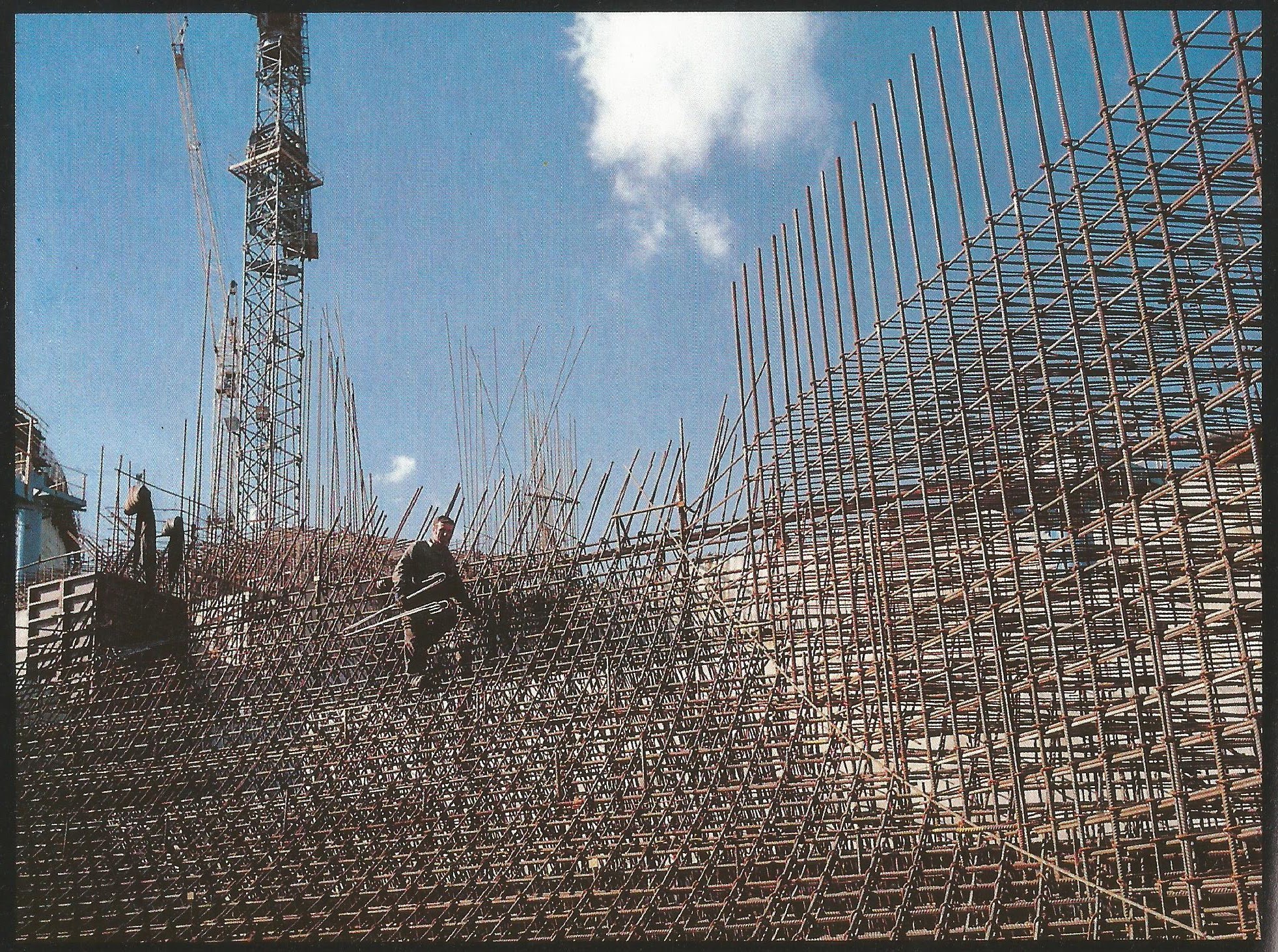
Constructions at Nagymaros, 1989. (Asztalos Zoltán)

Visegrád, 1988. (Weress Kálmán)

Visegrád, 1988. (Weress Kálmán)

The Nagymaros desert 1989. (Weress Kálmán)

Nagymaros and Visegrád, 1992. (Weress Kálmán)

Bős, 1986 (Kisbenedek Attila)

Bős, 1986. (Balaton József)

Vajka, 1991 (Cseke Csilla)